#Pagham in West Sussex England
Explore tagged Tumblr posts
Text

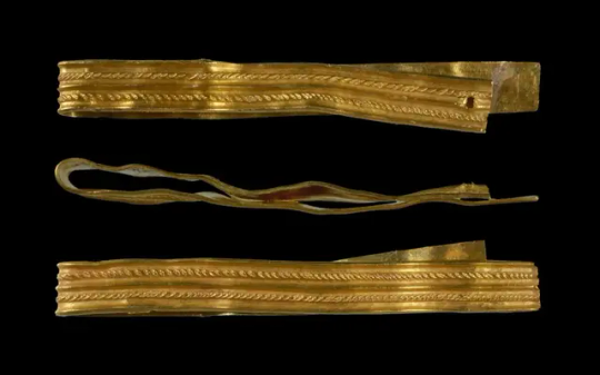
A 2,000-Year-Old Gold Roman Bracelet Found in England
A 12 year old boy and his mother have discovered a Roman bracelet whilst walking their dog near the village of Pagham in West Sussex, England.
The discovery is an armilla type cuff bracelet, an armband awarded as a military decoration (donum militarium) to soldiers of ancient Rome for conspicuous gallantry.
Roman legionnaires and non-commissioned officers below the rank of centurion were eligible for an armilla, which were worn at military parades or during a Roman Triumph to publicly celebrate and sanctify the success of a military commander.
The bracelet dates from the 1st century AD and has been declared as “treasure” by a coroner’s inquest, as the object (designated SUSS-417291) is more than 300 years old and is made from gold.


According to the Portable Antiques Scheme which recorded the find, the bracelet is a folded strip of sheet gold with five raised parallel mouldings with rib and rope styles. There are visible file marks and a circular piercing made at one end from the back through to the front.
The discovery was made by Rowan Brannan from Bognor, Sussex, who reported the find to the local Finds Liaison Officer. Archaeologists examined the artefact and authenticated it as genuine piece of ancient Roman gold jewellery.
Pagham is located not far from the Romano-British city of Noviomagus Reginorum (modern-day Chichester), capital of the Civitas Reginorum.
Noviomagus Reginorum began as a winter fort for the Second Augustan Legion shortly after the Roman invasion in AD 43. The fort was garrisoned for only a few years, before being developed as a Romano-British civilian settlement in the territory of the friendly Atrebates tribe.
By: Mark Milligan.

#A 2000-Year-Old Gold Roman Bracelet Found in England#Pagham in West Sussex England#gold#gold jewelry#ancient jewelry#ancient artifacts#archeology#archeolgst#history#history news#ancient history#ancient culture#ancient civilizations#roman history#roman empire#roman legion#roman art
42 notes
·
View notes
Text
The Town That Isn't There
Here's a fictional place fact post for you! Welcome to my twisted little world...
The location of my fictional town, Pagham-on-Sea, East Sussex, is roughly where Norman's Bay is in real life, but I've changed the geology and added a chalk spar that creates cliffs that aren't really there. This is so I can have cool things coming out of the rocks, but also to deliberately create a sense of unease and unfamiliarity about the area itself, so it's hard to pin down by description and signals that it's fictional and not real.
I went there to check out where things would sit geographically, and I think the layout works. @dewiwrites made me a town map that's in the hardback version of THE CROWS, and will also go in the eBook/paperback version of REAL MEAT when that comes out.
Here's the video of me going for a birthday walk in January along the very stretch of coast where Pagham-on-Sea is not.
youtube
I came up with the name just by running through prefixes and suffixes that work in the area, so -ham was the obvious ending as I wanted something in Old English to give it that sense of long history, and the prefix Pag- could have a number of folk etymologies while the real one is more mundane. It also just sounded right.
I then realised there is, of course, a real place called Pagham that's in West Sussex, near Chichester, and that just made it sound more authentic. So this one is Pagham-on-Sea, like its neighbour, the very real Bexhill-on-Sea, and the other one is just Pagham.
More info in the blog post below, with maps so you can see where it is in England if you're unfamiliar with the geography of English counties!
#pagham on sea factoid#pagham on sea posts#pagham on sea#writerscommunity#writerscorner#writers on tumblr#writersofinstagram#writeblr#cosmic horror#books books books#stuff i wrote#fictional folklore#fictional places#world building#worldbuilding#Youtube
16 notes
·
View notes
Video
Busy Selsey High Street by Adrian Pink Via Flickr: Selsey is a seaside town and civil parish, about eight miles (12 km) south of Chichester in West Sussex, England. Selsey lies at the southernmost point of the Manhood Peninsula, almost cut off from mainland Sussex by the sea. It is bounded to the west by Bracklesham Bay, to the north by Broad Rife (rife being the local word for stream or creek), to the east by Pagham Harbour and terminates in the south at Selsey Bill. There are significant rock formations beneath the sea off both of its coasts, named the Owers rocks and Mixon rocks. Coastal erosion has been an ever-present problem for Selsey. The B2145 seen here is the only road in and out of the town crossing a bridge over the water inlet at Pagham Harbour at a point known as "the ferry". At one time Selsey was inaccessible at flood tide, and a boat was stationed at the ferry to take horses and passengers to and from Sidlesham. en.wikipedia.org/wiki/Selsey
#Selsey#busy#High Street#street#B2145#car#vehicle#zebra crossing#Crossing#bus#bicycle#bike#people#man#woman#shop#shopping centre#village#Chichester#Sussex#West Sussex#England#summer#July#1975#20th Century#Drug Store#Manhood Peninsula
0 notes